Thursday, October 30, 2008

din-o'-lantern

I really didn't think this was going to be more complicated than last year's Maverick-o'-lantern, but three hours later, I was proven wrong.

I now present... The din-o'-lantern:


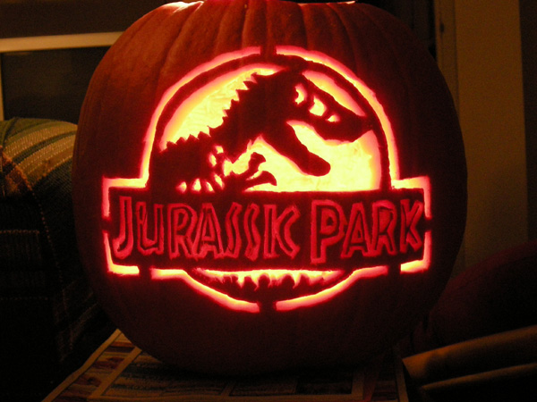
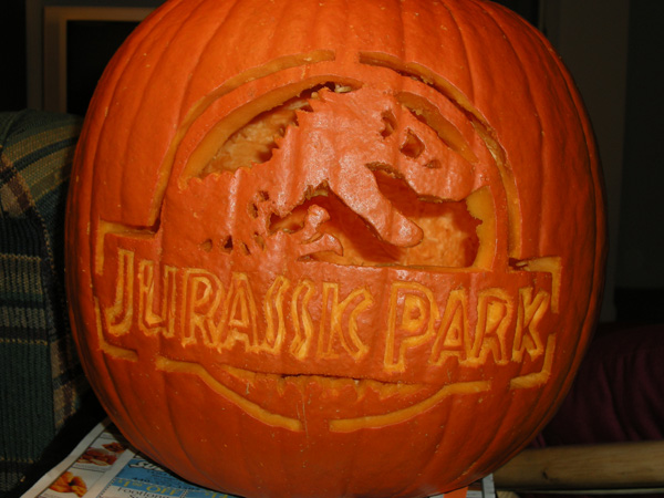
The most time-consuming parts were the letters, not because of the shapes, but because I chose not to cut all the way through. I thought that would be easier than trying to keep all the little lines attached, but it probably would've been easier than digging out the pumpkin skin (there's probably a better way, but I've never used that technique before). I eventually got the grand idea to shave away some of the meat behind the letters to allow more light through, which saved that experiment from disaster.

I realize my T-Rex doesn't have teeth, but by then it was 2 a.m. and I didn't care. It took a half hour to poke the design, an hour to carve the graphic, then an hour and a half to do the stupid letters and tweak/cleanup the design to allow more light to pass.

I'll set it out on my patio for Halloween, and since everyone leaving the parking lot across the drive gets a full-frontal view of said patio, at least someone will see it. I'm also going to my parents' house on Elyria's trick-or-treat night to celebrate my brother's birthday, so I'll take the din-o'-lantern and set it out on their porch as well.

And lest anyone think I'm out of date in carving the Jurassic Park logo, I'd have thought so too until a few weeks ago when I saw they were still selling Jurassic Park merchandise in stores. The first movie came out in 1993, but there have been two sequels (with an alleged fourth on the way), so I guess that keeps it current with today's kids. Now where's my cane, dagnabbit.

Edited to add: I just realized this is the 400th post on my blog!

Friday, October 17, 2008

shoddy modern construction

To eliminate one of many railroad grade crossings in North Ridgeville, a few years ago the city built a bridge along Avon-Belden Road/State Route 83. Because there were homes and businesses in close proximity to the tracks, simply building a bridge straight across would not be feasible since it would cut off driveways to these properties. Instead, the road was curved to the west and built on vacant land there, while the original Avon-Belden Road was snipped at the old crossing and turned into two culs-de-sac*.

*Believe it or not, "culs-de-sac" is the proper plural of this term. I don't like it either, but that's what we're stuck with.

I feel sorry for people who live there, first off because -- as far as I can tell -- the street was not renamed to anything like "Old Avon-Belden," as is usually done in cases like this (see "Old Grayton" by Cleveland Hopkins), so giving directions to people is difficult I'm sure. Secondly, because the former railroad crossing was closed, people who used to be neighbors no longer are, and going north on SR 83 from the south side of the tracks now requires going the opposite direction to connect with the bridge.

All of that is a long-winded way of getting to my main point of this post, which is the incredibly shoddy construction on this bridge which just opened not even two years ago. I was flying around Google Maps and noticed this:


Look at that! The right half of the bridge is already falling apart! It's as if someone took a Photoshop soft eraser to the northbound lane!

I kid, of course. I presume it's an artifact of how Tele Atlas stitches their satellite photos together. It reminds me of the time I was showing Stu where the recycling bins were in Strongsville, and noticed that the city only had half a water tower:


Frankly I'm just impressed that Google Maps even knows about the "new" Avon-Belden route; I wish my GPS were that up-to-date. My apartment's street doesn't even exist on my GPS, and Cherry Tree Drive is marked as the driveway for the apartments next to me, which is actually just an extension of Whitney Road. I've submitted the correction to TomTom, but haven't seen an update yet.

Interestingly (well, to me anyway), Google Earth had this same error, but Google Maps did not, because they used map data from different sources. I say "did," past-tense, because I see Google Maps is now using Tele Atlas as well, and likewise shows the incorrect Cherry Tree Drive. Annoying.

Tuesday, October 14, 2008

everything's coming up bacon

Everything Is Better Wrapped in Bacon
(Be sure to click on to page 2 as well.)

Bacon-wrapped cinnamon rolls made me laugh out loud. I'm not saying I wouldn't try it though. Really, I don't think it's any more ridiculous than wrapping a water chestnut in bacon and dipping it in BBQ sauce.

Wednesday, October 08, 2008

man decorates walls with sharpies

This seems like something I should do when I own a house:

Man Decorates Basement With $10 Worth of Sharpie

He also has a pinball machine in the basement, which is something else I want (next to the Ms. Pac-Man machine).

Thursday, October 02, 2008

some movies would be a lot shorter if the characters had cell phones

The title pretty much sums it up:

Some Movies Would Be a Lot Shorter if the Characters Had Cellphones

In other news, this is the last weekend for Company, so... yeah. Come see it.